Name
ST_MapAlgebraExpr — 2个栅格波段版本:创建通过对提供的两个输入栅格波段应用有效的PostgreSQL代数运算形成的新单波段栅格。如果未指定波段编号,则假定每个栅格的波段1。生成的栅格将在第一个栅格定义的栅格上对齐(缩放、倾斜和像素角),其范围由“extenttype”参数定义。“extenttype”的值可以是:交集、并集、第一个、第二个。
Synopsis
       raster

        ST_MapAlgebraExpr

       (
raster
rast1
, raster
rast2
, text
expression
, text
pixeltype=same_as_rast1_band
, text
extenttype=INTERSECTION
, text
nodata1expr=NULL
, text
nodata2expr=NULL
, double precision
nodatanodataval=NULL
)
;
       raster

        ST_MapAlgebraExpr

       (
raster
rast1
, integer
band1
, raster
rast2
, integer
band2
, text
expression
, text
pixeltype=same_as_rast1_band
, text
extenttype=INTERSECTION
, text
nodata1expr=NULL
, text
nodata2expr=NULL
, double precision
nodatanodataval=NULL
)
;
描述
![[Warning]](images/warning.png)
|
|
|
ST_MapAlgebraExpr 从2.1.0开始不建议使用。使用 ST_MapAlgebra(表达式版本) 取而代之的是。 |
通过对由定义的两个波段应用有效的PostgreSQL代数运算来创建新的单波段栅格
expression
关于两个输入栅格波段
rast1
、(
rast2
)。如果没有
band1
,
band2
是指定的,则假定为带1。生成的栅格将在第一个栅格定义的栅格上对齐(缩放、倾斜和像素角)。生成的栅格将具有由
extenttype
参数。
- 表达式
-
涉及两个栅格的PostgreSQL代数表达式和PostgreSQL定义的函数/运算符,它们将在像素相交时定义像素值。例如([rast1]+[rast2])/2.0)::整数
- 像素类型
-
输出栅格的结果像素类型。必须是中列出的 ST_BandPixelType 、省略或设置为空。如果未传入或设置为空,则默认为第一个栅格的像素类型。
- 区段类型
-
控制生成的栅格的范围
-
INTERSECTION-新栅格的范围是两个栅格的交点。这是默认设置。 -
UNION-新栅格的范围是两个栅格的并集。 -
FIRST-新栅格的范围与第一个栅格的范围相同。 -
SECOND-新栅格的范围与第二个栅格的范围相同。
-
- Nodata1expr
-
一种仅涉及
rast2或一个常量,该常量定义当像素的rast1是无数据值,并且空间上对应的rast2像素具有值。 - Nodata2expr
-
一种仅涉及
rast1或一个常量,该常量定义当像素的rast2是无数据值,并且空间上对应的rast1像素具有值。 - Nodatandataval
-
当空间上对应的rast1和rast2像素都为无数据值时返回的数值常量。
如果
pixeltype
则新栅格将具有该像素类型的带。如果传递的像素类型为空或未指定像素类型,则新栅格波段将具有与输入相同的像素类型
rast1
乐队。
Use the term
[rast1.val]
[rast2.val]
to refer to the pixel value of the original raster bands and
[rast1.x]
,
[rast1.y]
etc. to refer to the column / row positions of the pixels.
可用性:2.0.0
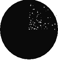
示例:两个标注栏交点和并集
从我们的原始创建一个新的1波段栅格,它是原始栅格波段的模2的函数。
--Create a cool set of rasters --
DROP TABLE IF EXISTS fun_shapes;
CREATE TABLE fun_shapes(rid serial PRIMARY KEY, fun_name text, rast raster);

-- Insert some cool shapes around Boston in Massachusetts state plane meters --
INSERT INTO fun_shapes(fun_name, rast)
VALUES ('ref', ST_AsRaster(ST_MakeEnvelope(235229, 899970, 237229, 901930,26986),200,200,'8BUI',0,0));

INSERT INTO fun_shapes(fun_name,rast)
WITH ref(rast) AS (SELECT rast FROM fun_shapes WHERE fun_name = 'ref' )
SELECT 'area' AS fun_name, ST_AsRaster(ST_Buffer(ST_SetSRID(ST_Point(236229, 900930),26986), 1000),
            ref.rast,'8BUI', 10, 0) As rast
FROM ref
UNION ALL
SELECT 'rand bubbles',
            ST_AsRaster(
            (SELECT ST_Collect(geom)
    FROM (SELECT ST_Buffer(ST_SetSRID(ST_Point(236229 + i*random()*100, 900930 + j*random()*100),26986), random()*20) As geom
            FROM generate_series(1,10) As i, generate_series(1,10) As j
            ) As foo ), ref.rast,'8BUI', 200, 0)
FROM ref;

--map them -
SELECT  ST_MapAlgebraExpr(
        area.rast, bub.rast, '[rast2.val]', '8BUI', 'INTERSECTION', '[rast2.val]', '[rast1.val]') As interrast,
        ST_MapAlgebraExpr(
            area.rast, bub.rast, '[rast2.val]', '8BUI', 'UNION', '[rast2.val]', '[rast1.val]') As unionrast
FROM
  (SELECT rast FROM fun_shapes WHERE
 fun_name = 'area') As area
CROSS JOIN  (SELECT rast
FROM fun_shapes WHERE
 fun_name = 'rand bubbles') As bub
|

地图代数交集
|
地图代数并
|
示例:将栅格作为单独的波段叠加在画布上
-- we use ST_AsPNG to render the image so all single band ones look grey --
WITH mygeoms
    AS ( SELECT 2 As bnum, ST_Buffer(ST_Point(1,5),10) As geom
            UNION ALL
            SELECT 3 AS bnum,
                ST_Buffer(ST_GeomFromText('LINESTRING(50 50,150 150,150 50)'), 10,'join=bevel') As geom
            UNION ALL
            SELECT 1 As bnum,
                ST_Buffer(ST_GeomFromText('LINESTRING(60 50,150 150,150 50)'), 5,'join=bevel') As geom
            ),
   -- define our canvas to be 1 to 1 pixel to geometry
   canvas
    AS (SELECT ST_AddBand(ST_MakeEmptyRaster(200,
        200,
        ST_XMin(e)::integer, ST_YMax(e)::integer, 1, -1, 0, 0) , '8BUI'::text,0) As rast
        FROM (SELECT ST_Extent(geom) As e,
                    Max(ST_SRID(geom)) As srid
                    from mygeoms
                    ) As foo
            ),
   rbands AS (SELECT ARRAY(SELECT ST_MapAlgebraExpr(canvas.rast, ST_AsRaster(m.geom, canvas.rast, '8BUI', 100),
                 '[rast2.val]', '8BUI', 'FIRST', '[rast2.val]', '[rast1.val]') As rast
                FROM mygeoms AS m CROSS JOIN canvas
                ORDER BY m.bnum) As rasts
                )
          SELECT rasts[1] As rast1 , rasts[2] As rast2, rasts[3] As rast3, ST_AddBand(
                    ST_AddBand(rasts[1],rasts[2]), rasts[3]) As final_rast
            FROM rbands;
|
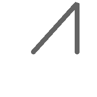
栅格1
|

栅格2
|
|

栅格3
|

final_rast
|
示例:将选定地块的2米边界覆盖在航拍图像上
-- Create new 3 band raster composed of first 2 clipped bands, and overlay of 3rd band with our geometry
-- This query took 3.6 seconds on PostGIS windows 64-bit install
WITH pr AS
-- Note the order of operation: we clip all the rasters to dimensions of our region
(SELECT ST_Clip(rast,ST_Expand(geom,50) ) As rast, g.geom
    FROM aerials.o_2_boston AS r INNER JOIN
-- union our parcels of interest so they form a single geometry we can later intersect with
        (SELECT ST_Union(ST_Transform(geom,26986)) AS geom
          FROM landparcels WHERE pid IN('0303890000', '0303900000')) As g
        ON ST_Intersects(rast::geometry, ST_Expand(g.geom,50))
),
-- we then union the raster shards together
-- ST_Union on raster is kinda of slow but much faster the smaller you can get the rasters
-- therefore we want to clip first and then union
prunion AS
(SELECT ST_AddBand(NULL, ARRAY[ST_Union(rast,1),ST_Union(rast,2),ST_Union(rast,3)] ) As clipped,geom
FROM pr
GROUP BY geom)
-- return our final raster which is the unioned shard with
-- with the overlay of our parcel boundaries
-- add first 2 bands, then mapalgebra of 3rd band + geometry
SELECT ST_AddBand(ST_Band(clipped,ARRAY[1,2])
    , ST_MapAlgebraExpr(ST_Band(clipped,3), ST_AsRaster(ST_Buffer(ST_Boundary(geom),2),clipped, '8BUI',250),
     '[rast2.val]', '8BUI', 'FIRST', '[rast2.val]', '[rast1.val]') ) As rast
FROM prunion;
|
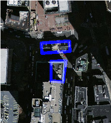
蓝线是所选宗地的边界
|
另请参阅
ST_MapAlgebraExpr , ST_AddBand , ST_AsPNG , ST_AsRaster , ST_MapAlgebraFct , ST_BandPixelType , ST_GeoReference , ST_Value , ST_Union , ST_Union